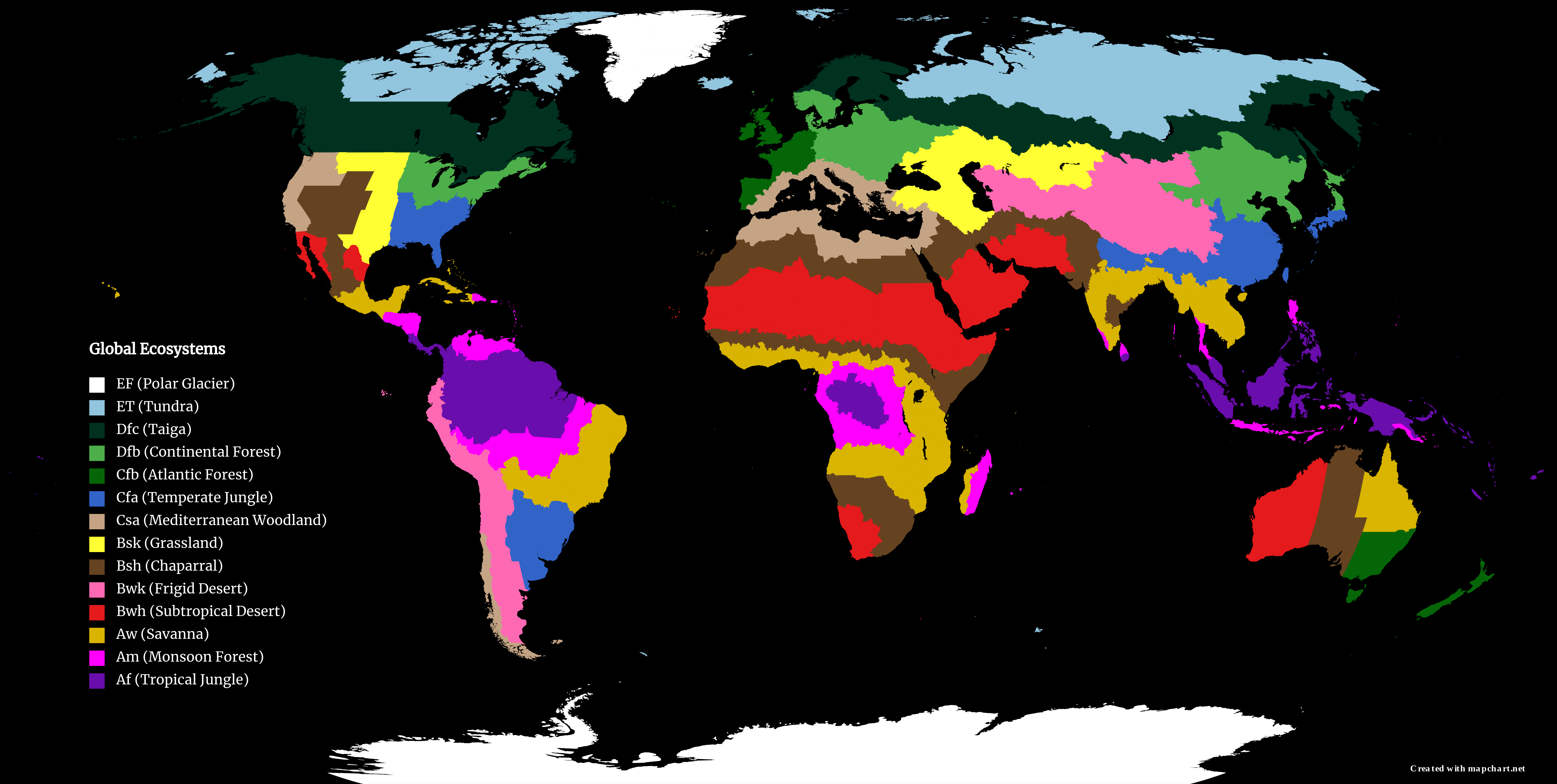
Click above map for larger, zoomable view
I created this world map to display the close association between the climate of a certain region and the ecosystem/biome that it possesses. Since both climate and biome formation are heavily influenced by the solar insolation (the angle of sunlight which is largely dependent on latitude) and the average annual precipitation, the strong correlation and overlap between them was to be expected. Koppen climates were specifically used for this project. Not all Koppen climates were used, however, as there were many instances where a biome would contain many climates (many of which rarely appeared and were confined to a small area in the globe). Moving onto the positives, all major biomes were able to be matched with the corresponding Koppen climates and all Koppen climates that occupied an area greater than Texas were able to be utilized.
Koppen Climate Key:
- E – Polar (Avg temp below -10℃; Avg precipitation below 50 cm)
- EF – Polar, Frigid (Avg temp below -20℃)
- ET – Polar, Tundra (Avg temp between -10℃ and -20℃)
- D – Continental (Avg temp between 10℃ and -10℃; Avg precipitation between 50 – 100 cm)
- Df – Continental, No Dry Season (Precipitation year round)
- Dfc – Continental, No Dry Season, Cold Summer (<3-month growing season)
- Dfb – Continental, No Dry Season, Warm Summer (>3-month growing season)
- Df – Continental, No Dry Season (Precipitation year round)
- C – Temperate (Avg temp between 10℃ and 20℃; Avg precipitation between 100 – 150 cm)
- Cf – Temperate, No Dry Season (Precipitation year round)
- Cfb – Temperate, No Dry Season, Warm Summer (Mild seasons)
- Cfa – Temperate, No Dry Season, Hot Summer (Hot, humid summer)
- Cs – Temperate, Dry Summer (Summer dry season)
- Csa – Temperate, Dry Summer, Hot Summer (Hot, dry summer)
- Cf – Temperate, No Dry Season (Precipitation year round)
- B – Arid (Avg temp above 10℃; Avg precipitation below 100 cm)
- Bs – Arid, Steppe (Avg precipitation between 100 – 50 cm)
- Bsk – Arid, Steppe, Cold (Snowfall during winter)
- Bsh – Arid, Steppe, Hot (No snowfall)
- Bw – Arid, Desert (Avg precipitation below 50 cm)
- Bwk – Arid, Desert, Cold (Snowfall during winter)
- Bwh – Arid, Desert, Hot (No snowfall)
- Bs – Arid, Steppe (Avg precipitation between 100 – 50 cm)
- A – Tropical (Avg temp above 20℃; Avg precipitation above 150 cm)
- Aw – Tropical, Dry Winter (Winter dry season)
- Am – Tropical, Monsoon (Monsoon-controlled seasons)
- Af – Tropical, No Dry Season (Precipitation year round)
